Showing posts with label mountains. Show all posts

Tuesday, January 31, 2017

Enjoying the freezing clouds of Tagaytay


There's always a first time, right Clarita! ðŸ˜Š

Two Sundays ago, we revisited Tagaytay, our favorite city. Except for Krystal whose school held its recollection there last November, our family hasn't visited the place since 2014. I was still pregnant with Junífera Clarita at that time. And last year, on our way to Burot Beach, we just passed by the place. So technically, this is Junífera Clarita's first time in our country's second "summer capital".


We are always excited to go to Tagaytay even though we have visited it many times already. For those who do not know yet, my hubby Pepe loves cold places (he always changes the thermostat of our air conditioning to its highest, LOL!). He's the type who prefers the rainy season, including typhoons! He finds dark skies romantic, so don't wonder anymore if you see him very happy within a dark forest. ðŸ˜Š

A breathtaking view of  Tagaytay!!!! 

Misty flowers.

Whenever we want to enjoy a place for its cold weather, especially on the coldest month of the year, Tagaytay naturally comes to mind because it is the nearest to our place. Baguio takes several hours to reach, probably six or seven. Even the mountain town of Luisiana, a place which is also in the same province as ours, can take up to three hours, but reaching Tagaytay takes only two hours. One if the traffic is OK. We left our place after lunch and arrived in Tagaytay at mid-afternoon. We went straight to "People's Park In The Sky" or "Palace In The Sky". Anyway, the main reason why tourists go to Tagaytay is to enjoy its mild climate. So why not visit its coldest place?

My first time to taste strawberry taho. =)


At the entrance.

This used to be, PEOPLE'S PARK IN THE SKY. Now it's T F S. LOL!


Merienda time! =) =)

After paying for the entrance tickets (₱30.00), we bought strawberry-flavored tahô (silken tofu with sago pearls). It was my first time to taste it. It was delicious. Then we experience the clouds when we were already there on top and taking pictures and selfies. While the kids were playing within the mists covering the park, I was ordering our merienda: fish balls, chicken balls, kikiam, french fries, and hot noodles. After eating our snacks, the kids continued playing, experiencing the moment that is so soothing to the senses. They don't get to play that much in our place. The park is cold, romantic, and awesome! It was also drizzling from time to time as the cold clouds continued to envelop us. Most people say that the thick mist covering People's Park In The Sky is fog, but the truth is those are clouds because the park is on top of a mountain. Many people just don't realize it because there is already a road leading towards the park. There is really no more need to climb.

We stayed up there until it got dark. As usual, we were one of those who were last to descend, hehehe! Our kids have learned to love cold temperatures just like my hubby. Like father, like children. ðŸ˜Š ðŸ˜Š


My hubby is very happy up here. =)


Un gato blanco.

So if you want to experience clouds and a cold atmosphere, you better come and go to People's Park In The Sky. Who knows? We might even bump into each other up there. 😊

Real Selfies! =)

We ❤ Tagaytay!!!!!!!


Totally CLOUDY!!!!!!! ðŸ˜ŠðŸ˜ŠðŸ˜ŠðŸ˜ŠðŸ˜ŠðŸ˜ŠðŸ˜Š
                                                           —Yeyette


DID YOU KNOW? The highest point in Tagaytay is Mount Súñgay, the place which everybody calls as "People's Park In The Sky" or "Palace In The Sky".  Its peak, according to Google Earth, stands at 2,351 feet above sea level.


Please click here for the complete photo album and don't forget to LIKE US on Facebook! ¡Gracias! =)

Sunday, April 24, 2016

Mt. Abra de Ilog: the green, rocky citadel of Mindoro Occidental

My very first mountain hike happened more than a decade ago. And it was in Abra de Ilog, Mindoro Occidental, my wife Yeyette's hometown. I was barely 21, and I had a couple of kids to accompany me (Yeyette's cousins, actually, who are now all grown up).

Monte Abra de llog. Photo taken from the balcony of Yeyette's ancestral home last 12 September 2011.
Flashback to the summer of 2001: the moment my eyes laid upon Abra de Ilog from its port, the first thing I noticed were the mountain ranges. I have never seen so much green heights in my life! There were mountain ranges everywhere. Beyond the small port, no houses, no town, could be seen. It's all mountains, hills, and forests. Before we disembarked from the ferry, I asked Yeyette: "where in the world is your house?" She didn't tell me that we had to travel another twenty minutes from the port to the town proper via tricycle. I was to learn days later, when I had already reached the peak of Monte Abra de Ilog, that the Población was tucked in between two rows of scenic mountain ranges. The first one, to the west, faces the Verde Island Passage. The second one, to the east, divides Mindoro Occidental from Mindoro Oriental.

Abra de Ilog is strategically located between these two green-tinged cordilleras.

Casa Atienza, Yeyette's ancestral home at the Población, faces the eastern mountain range that includes Mount Abra de Ilog. The house has an unbalustered balcony where one could have a perfect vantage point to view the mountain range. It was there where I, as a young father to Krystal, have spent many countless hours observing every nook and cranny of the irregularly shaped massifs. Upon first glance, I thought the mountain ranges were the victims of a blatant case of deforestation because there were not much trees up there, only grass and scraggly rock formations. There is even a huge scar which I first attributed to what I thought was once a mining area. I was mistaken. The peaks of the mountain ranges turned out to be rocky, impossible thus for a small forest to even survive. The huge scar, according to residents, has been there even before they were born; I therefore suspect that it's a huge fault or heaven forbid— the crater of a long-dormant volcano.

That part of Yeyette's ancestral home —the balcony— has been my favorite part of the house because I've never lived that close to a mountain. I grew up for the most part in urban dwellings, that is why Abra de Ilog's natural serenity was something refreshingly new for me. It ignited a spark from within which has never since extinguished.

Each day of that memorable summer of 2001, I was feeding my eyes with Mount Abra de Ilog's greenish scenery delights. One time, I noticed a man-made structure towards the north near the summit. It turned out to be, by the looks of it, a radio tower of some sort. The thought intrigued me. If a telecommunications tower can be set up from that elevation, then it's not impossible to hike that mountain! So I asked around what that tower was all about. The answer I got was that it was a cell site (meant to create a cell in a cellular network). Yeyette's Tito Raf told me that he was part of a group of laborers who constructed it during the 90s. Yeyette's cousins, most of who were still in elementary school, said that they have all gone up there many times. They then asked me if I wanted to join them for a fun climb — excitement filled me like strong water from a faucet filling a dry bucket. I was about to experience my first mountain hike! Me, who have grown accustomed to city traffic and buildings and concrete roads and polluted air!

We set out towards the tower. When we reached the structure by midday, I remember having seen a caretaker who never even bothered looking at us. So we climbed towards the rooftop of the two-story building beside the tower. I also remember having seen a logo of "Digitel" there. From the rooftop, we had a perfect 360º view of Abra de Ilog and even the Verde Island Passage. It was a tiring experience; my legs turned rubber the day after. But it was a fun one nevertheless, an exhilarating climb  my very first! I remember how all exhaustion had left my body once I've reached the top and have seen the world below me. So that's what mountain climbing is all about!

After a few days, I climbed that mountain again, but on my own, with the goal of going beyond the tower, to reach the mountain's highest peak. Armed with a bolo from Yeyette's grandfather (may he rest in peace), I was dressed in a long-sleeved camiso de chino to protect me from the sun. That climb turned out to be the most adventurous part of my life. I left before the sun was up, reached several peaks, not knowing back then that what I was up against was not a single mountain but a group of mountains. And I had seen stuff that I was never able to see again — I encountered a dense and eerie forest far below me, gigantic, lifeless trees, and even a "mini garden" with low grass and exotic flowers of vibrant colors.

But I got lost along the way when it got real cloudy. Then it drizzled when it was past five in the afternoon. I was very afraid: I could see the town proper below, but a huge forest was between us. I might not survive the night if I go straight through it. Fortunately, as I was desperately looking for a trail that will send me home, I saw a Mañguián lad who gave me directions back to the tower. That's why when I got home, it was already dusk. Yeyette, carrying an infant Krystal, cried when she saw me by the door, and Tito Val scolded me out of concern. I was filled with dirt and mud. My long-sleeved shirt didn't protect me from getting sunburned. I had scratches and dried blood on both arms. The bolo which I borrowed from Yeyette's grandfather was already gone — I lost it in a forested area up in the mountain where I slipped on an incline towards what seemed to be a quicksand of some sort; I got away when I held onto some bushes and vines.

It was one of the greatest things that I have ever done in my life! Since then, whenever we go to Abra de Ilog, I make sure to climb it, but with a companion, usually Yeyette's cousins. My last climb there was on 29 March 2006 (Red's will be familiar with the date; but no, this mountain is totally safe from any communist or military activity).

Fast forward to April 4, just a few weeks ago. Krystal is already a dalaga, and my son Mómay is nearing 12. If a decade ago Yeyette's cousins were able to accompany me up the mountain at such a young age, I believed that my children —except for Jefe, Juanito, and Junífera Clarita, of course could tag along. Actually, we've been planning on it for a long time now.

We set off a few minutes past seven in the morning with Yeyette's teenage cousin John-John, bringing along with us a couple of gallons of water and several pieces of bread filled with scrambled eggs prepared by Yeyette for nourishment. Since it was to be Krystal and Mómay's first time to climb, our goal was to simply reach the tower, then go home by lunchtime.

Can you see the tower? That's where we're headed.

The hike starts right here.

¡Ang taás na namin!

My kids surprised me because we reached the tower in just an hour and a couple of minutes. Mómay never even showed signs of weariness. It was simply an exciting experience for both, and it gave me pure joy to see them both overjoyed.

The next thing I noticed is that there was a second tower. A new one. I never noticed that from below. And there was already an electrical line from the town all the way to the new tower. So much has changed since the last time I climbed the place. Nevertheless, the place is still forested. Nature wasn't harmed, just the way we nature lovers want such places to be.

At the old, deserted building of Abra de Ilog's first radio mast and tower. This cell site stands at an altitude of 1,130 feet above sea level. Nobody else was here but us. The people over at the new tower which lies just a few meters away never even bothered us.

After eating our báon at the rooftop, we decided to climb some more beyond the tower.

The sun may be up high, but it's already cold up here! At left is Barrio Uauà (where Matabang River drains) and the Port of Abra de Ilog.

Facing the wide expanse of the Verde Island Passage. The cool breeze from that huge body of water is upon us!

The jagged, grassy peaks of Mount Abra de Ilog. They seem to be near, but they're about a kilometer or two away from where this photo was taken.

The town proper is far away below! On the other side are the mountain ranges of Burburuñgan. Beyond those peaks is Monte Halcón and the province of Mindoro Oriental.

We kept on walking till we reached an elevation of about 1,400 feet above sea level. But we had to go because Krystal was getting weary. Understandable, since it's her first climb. But she and Mómay are still raring to go for more climbs after Mount Abra de Ilog. This mountain from their mom's incredible home town has inspired them to conquer more peaks in the future the way it has inspired me more than a decade ago.

I hope to bring the rest of the family up there one day.


There's a new mountain destination in Abra de Ilog called "Cruz Na Parang". According to those who have already climbed there, the peak is much higher compared to that of Mount Abra de Ilog. The starting point is in Barrio Lumangbayan. I'll certainly be writing more about it once we've hiked it on our next visit to Abra de Ilog. In the meantime, click here for the complete photo album of our Mount Abra de Ilog fun climb! ¡Hasta la vista!

Saturday, January 25, 2014

Getting high in Tagaytay

One day, a long time ago, when huge forests still covered the chilly parts of what is now known as Southern Cavite, a young native accompanied his father to hunt for wild boar. They searched the green ridge which fronts a silvery lake with a temperamental island in its midst called Bombón.

A long time ago, Taal Volcano was known as Bombón, an onomatopeic name given by the natives because of the volcano's booming sounds during explosions. In Tagaytay, this world-famous Batangueño volcano can be viewed from different vantage points.

After a long search for a quarry, they found a huge boar deep within the cold forests of the ridge. The chase was on. Accustomed to hunting, both father and son were nearly as fast as the boar. The hapless animal soon became aware of this, thus it had no other choice but to stop dead on its tracks, turn around, and attack its hungry pursuers. Father and son were surprised with the animal's desperate attempt for survival. In great panic, the boy alerted his father to immediately strike the beast with his bolo. "¡Tagâ, Itáy! ¡Tagâ, Itáy!"(Strike it, father, strike it!)

The frightened screams reverberated throughout the jungle, the valleys, and the ridge. It was heard by nearby residents and woodcutters. Puzzled with all that ruckus from the forest, the boy's screams soon became a hot topic among the peaceful natives. In the course of time, the surrounding area where the "¡Tagâ, Itáy!" echoed became known as "Tagaytay".

Filipinos are fond of legends explaining the origin of place names. In the Age of Information, legends like this are no longer acceptable. Nevertheless, they still titillate the minds of many. Even revolutionary Emilio Aguinaldo found it worthwhile to include in his memoirs another similar legend on how Tagaytay got its name:
While we were resting, an old friend of mine who used to hunt in Tagaytay told me how the place got its name. According to him, a Spaniard from Taal went up to Tagaytay one morning. There he met an old man and his son doing a caiñgin* apart from each other. The Spaniard asked the father for the name of the place:
"¿Cómo se llama este sitio?" (What is the name of this place?) But they did not understand each other because the old man did not speak Spanish. Because of miscommunication, the hot-headed son from afar impatiently cried to his father: ¡Tagâ, Itáy! ¡Tagâ, Itáy! (Strike him, Father! Strike!). So the Spaniard exclaimed, "¡Ah, Tagaytay!"
(From Aguinaldo's Mga Gunita ng Himagsikan; translation mine).
I wonder how deep Aguinaldo's Tagalog was. Didn't he even know that Tagaytay is a Tagalog word for ridge? Maybe because he spoke more Spanish than Tagalog. But what about Tagalogs today? How come they don't even know this? Too much Taglish and English? Anyway, the term "Tagaytay Ridge" is redundant because both words mean the same thing.

This may all seem trivial to many for what matters the most is Tagaytay's magnetic appeal: its favorable climate and relaxingly awesome sceneries. This Caviteño city by the ridge has become the favorite haunt of millions of city dwellers, particularly those from the Metro Manila area, to escape the urban heat. Because of its nippy climate and outstanding vista of the forested ridge and Taal Lake and Volcano in Batangas, it has become one of the country's most popular tourist destinations. Add to that its proximity to the National Capital Region.

We visited Tagaytay —for the nth time— last January 12 not only to enjoy the cold, refreshing air but also as a treat to Jefe who was to celebrate his seventh birthday the following day, a Monday. That's why we thought of giving him a birthday pasiál a day earlier.


A relaxing view of Mahogany Avenue. This road leads to where the City Hall complex is (to the left). We were on our way to Mahogany Market for lunch.

We arrived in Tagaytay by lunchtime, so we had to eat. Preggy Yeyette was then craving for some steamy bulaló**. The people at the Tagaytay Public Market recommended that we visit Mahogany Market which is near the city hall. So off we went there. I have to admit that I frowned upon arrival because I'm used to eating in fancy restaurants. Not that I'm "sosyál" or anything, but it's just that I'm not really used to eating in such places. And the huge crowd that met us really turned me off. However, this crowd was different. They're not just ordinary peeps but those with big, shiny cars. Some even brought with them their well-groomed dogs. And they were all dressed smartly. All these trappings betrayed their social status. This means that Mahogany Market's bulaló stalls are of good reputation. They're not just ordinary carinderia stalls. And yes, their bulaló and fried biyá*** is as at par with those fancy restaurants that I adore.

For those who do not know yet, the average altitude of Tagaytay is around 2,200 feet above sea level (FASL) which is a little less than half of Baguio's 5,050 FASL. The southern and eastern portions of this component city are covered by hills and mountains which are still generously covered by forests and open grasslands. The city lies along the redundant name Tagaytay Ridge which stretches about 32 kilometres from Mount Batuláo in the west (Nasugbú, Batangas) to Mount Suñgay (People's Park in the Sky) in the east. The ridge overlooks Taal Lake and its volcano, and this perfect vista allowed Tagaytay to enter the tourism industry. Many tourist lodges, hotels, and specialty restaurants have sprouted throughout the years (me and Yeyette had a memorable stay at The Lake Hotel during our honeymoon last year). A favorite hangout of ours is One Destination, a strip of fancy restaurants and bars, because of its relaxing view of the lake. My favorite spot there is a branch of Starbucks Coffee where I could sit all day gazing at the majestic beauty of Taal's Volcano Island while sipping some cold coffee beverage while (with some book of course). These tourist establishments have become the source of much of the city's income. 

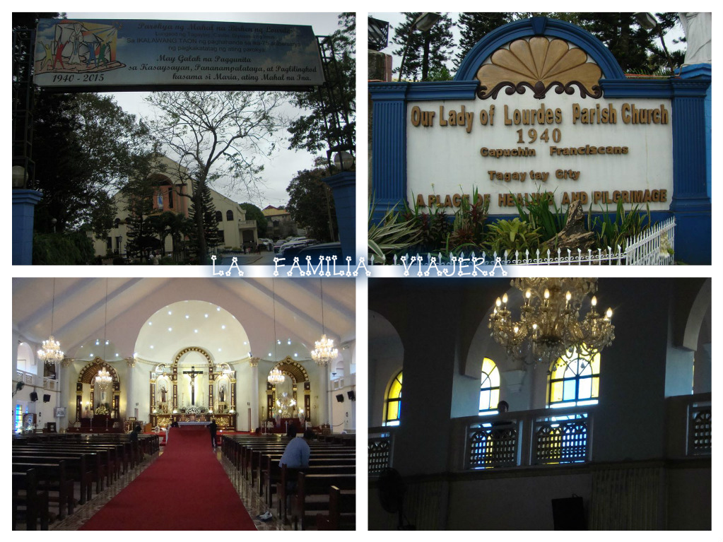
But Tagaytay also has many other tourist spots that we have not yet visited such as the Japanese Friendship Garden, and The Puzzle Mansion, Sky Fun (where the country's tallest ferris wheel could be found), and Tagaytay Picnic Grove. Last January 12, we went to the Nuestra Señora de Lourdes Church which we have not yet visited before.

Right after lunching at Mahogany Market, we visited this sacred place.
Iglesia de Nuestra Señora de Lourdes. This structure is actually a newer version as it was inaugurated and blessed only on 12 February 2003 and was consecrated on 2 February 2008. On both occasions, Church rites were officiated by then Diocese of Imus Bishop Luis Antonio Tagle who is now the Archbishop of Manila (and Cardinal-Priest of San Felice da Cantalice a Centocelle). The old church is toward the southwest of the church grounds.


Momay, Yeyette, Juanito, and Krystal in front of the original structure of Our Lady of Lourdes. Built by the Order of Capuchin Friars Minor in 1940, it is the oldest edifice in Tagaytay. Our Lady of Lourdes is a patroness of these friars. Interestingly, they used to have a church in Intramuros that was also dedicated to Our Lady of Lourdes. Additional trivia: I was also baptized in a church in Lucena, Tayabas (now Quezon) province which is also dedicated to Our Lady of Lourdes.

After a brief prayer and tour at the church, we then proceeded to our most favorite spot in Tagaytay: where else but in People's Park In The Sky?! Yes, we like it higher and colder!

The scenic "People's Park In The Sky" on top of Mount Suñgay. But due to poor management, this place is now called "Eople's K N The Sky".

 view of Taal Lake and its Volcano Island. The road below is the Tagaytay-Calamba Road which connects this part of Cavite to La Laguna province.
At 2,351 FASL, Mount Suñgay/People's Park In The Sky is the highest point in Tagaytay. On a clear day, one can see from here not just Taal Lake but also Laguna de Bay and the bays of Manila, Balayán, and Batangas.

It's not cold up here... it's FREEZING!

The park is covered with clouds. Yes, clouds, not fog. Because this place is on top of a mountain.

People's Park In The Sky was an unfinished project by former First Lady Imelda Marcos. It is situated on top of Monte Suñgay. Years ago, a couple of wiseguys who thought they were more intelligent than their house rats changed its name to Mount Nicolás Gonzales in honor of the patriot who was once stationed there. Thankfully, nobody today is buying that historical crime. Caviteños such as my father-in-law still call it Suñgay.

Anyway, the place was to be called Palace In The Sky when construction started there in 1979 (casíng bata co palá itó). It is said that Mount Suñgay was leveled to about half of its former prominence to accommodate the mansion that was originally intended as a guesthouse for former California Governor Ronald Reagan who never arrived. When the 1986 People Power Revolution broke out and toppled the Marcos dictatorship, construction was halted. The half-finished mansion can still be seen at the site. It was renamed People's Park In The Sky.

We stayed until the skies got dark and we were the only tourists left there. The place was well-lit. However, thick clouds covered the site, exuding a beauty that is both freezingly eerie and captivating at the same time. People's Park In The Sky is worth seeing this way!

The bright lights of the mist-covered Shrine of Our Lady, Mother of Fair Love and the enormous statue of Our Lord and Savior Jesus Christ give out a terrifyingly beautiful effect. This small shrine was inaugurated on Valentine's Day 2003 and was blessed also by then Bishop Tagle.

Before going home, we had dinner at Bali Seafood Palutò. We feasted on steamed mussels with sweet Thai chili, blue marlin, tinolang halaán or clam stew, grilled eggplant salad, and leche flan for dessert. Their hot clam stew was the perfect complement to the cold weather.

But Tagaytay is more than just a tourist spot and a place for spiritual renewal. It also had its fair share in Philippine History. During the Tagalog rebellion against the Spanish regime, Tagaytay served as the connecting link between Cavite and Batangas where many rebels were situated. Tagaytay was nothing but jungle when Aguinaldo and his troops passed it en route to Talisay, Batangas where they captured the entire 72nd Battalion of the Spanish colonial army. It is also interesting to note that about a third of Tagaytay's total land area used to belong to the wealthy Laurel clan of Batangas. But they had it sold to pay for lawyer's fees when a young José P. Laurel, Jr. (who was to become the country's president during the Japanese Occupation) got involved in a stabbing incident.

This Tagaytay trip was our early birthday treat for Jefe.

We Filipinos are a tropical people. As such, we get excited whenever there is a drop in temperature because we have been dealing with the heat for most part of the year. Even during the rainy season, it almost immediately heats up right after a typhoon. That is why we love to punish ourselves whenever this time of the year arrives by going to places such as Baguio and Tagaytay where temperature becomes ice-cold from December to February.

My family has been to Tagaytay many times already as it is our favorite city, mainly because of its cool climate. We've been here several times but we never get tired of visiting it. And what makes it enticing for us to visit Tagaytay that often is because of its proximity to our place. Recently, we've noticed a spike in land development. Several villages and buildings have sprouted here and there. Nevertheless, we are thankful that Tagaytay has not lost its charm and beauty.

But hey, it's not just that famous view of Taal Volcano that makes us visit Tagaytay over and over again. It's not just the place's altitude, nor its preferrable climate, nor its strategically located restaurants, nor its very friendly people. It's Tagaytay's totality itself that makes us keep on coming back.

Click here for more photos of our cold Tagaytay escapade!

♥L♥A♥F♥A♥M♥I♥L♥I♥A♥V♥I♥A♥J♥E♥R♥A

TRIVIA: Tagaytay was originally Aguinaldo's choice as the capital of the Philippines because of its strategic military value as well as its potential as a summer capital. He opposed plans of making Novaliches, a former town that is now a district in Quezon City, as the capital because it is within cannon range of battleships in Manila Bay. Many years later eventually, Quezon City became the capital of the country. Aguinaldo's choice may have been proven correct because during the Japanese Occupation on 3 February 1943, the U.S. 511th Parachute Regiment of the 11th Airborne Division chose Tagaytay Ridge as the site to airdrop military supplies and personnel. From there, they launched a massive northward offensive towards Manila.

Dark, foreboding skies. But no, it didn't rain nor drizzle during our visit.

♥L♥A♥F♥A♥M♥I♥L♥I♥A♥V♥I♥A♥J♥E♥R♥A

*Clearing land of grass and trees for cultivation
** A steaming bowl of beef shanks with bone marrow usually with pechay, potatoes, corn, and sometimes a few sliced of sabá, a type of banana.
*** Dwarf pygmy goby (Pandaka pygmaea).

Special thanks to the Philippine Daily Inquirer for mentioning our Tagaytay trip!